지리·지질 인문학
Geographical-Geological Humanities
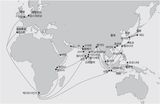
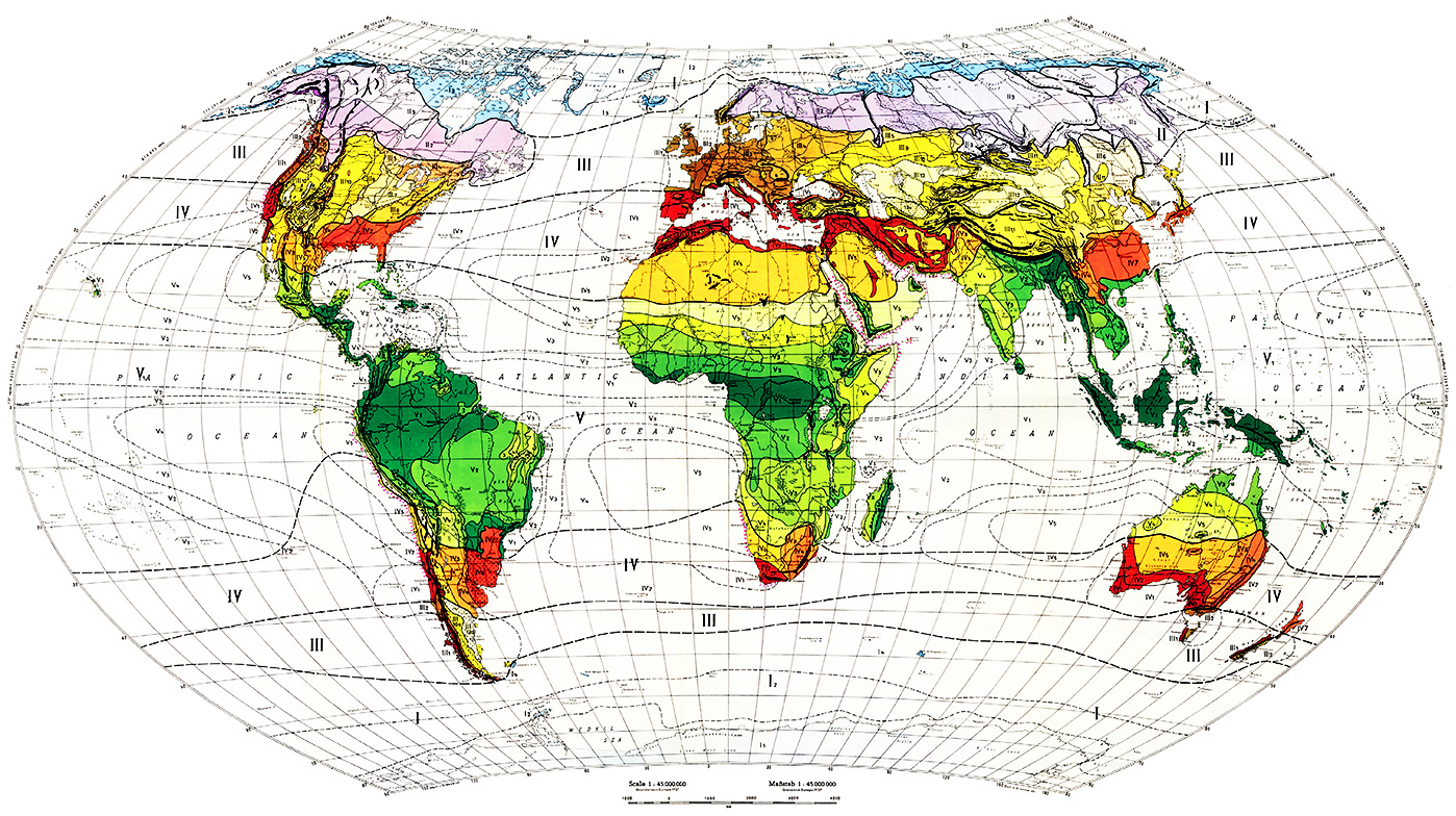
네덜란드 동인도회사의
열대 해양무역 항로와 해항도시
네덜란드 동인도회사(VOC)는 인도양과 동남아시아의 주요 해양무역 도시에 상관들을 설치했다. VOC는 젤라디아(타이완)와 류큐(오키나와)를 거쳐서 데지마에 이르기까지 광범위한 해양무역 네트워크를 만들어갔다. VOC는 무역회사인 동시에 군사기구였으며, 네덜란드가 ‘해양 주권’을 장악하는데 없어서는 안 될 외교기관이기도 했다.
The Dutch East India Company's Tropical Marine Trade Route and Seaport Cities
The Dutch East India Company (VOC) established supervisors in major maritime trading cities in the Indian Ocean and Southeast Asia. The VOC has established an extensive maritime trading network, from Geladia (Taiwan) and Ryukyu (Okinawa) to Dejima. The VOC was both a trading company and a military organization, as well as an indispensable diplomatic entity for the Netherlands to assert control over "marine sovereignty.“
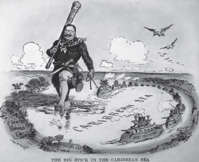
시어도어 루스벨트의 카리브
그는 미국의 힘이 대서양과 태평양에 모두 미치는 것으로 명확하게 인식한 최초의 대통령이었고, 더 나아가 미국이 거대 세력으로 부상할 곳이 바로 태평양이라고 인식하여 거대 규모의 해군을 세우려고 한 최초의 대통령이었다.
The Caribbean Sea of Roosevelt
He was the first president to clearly recognize the power of the United States affecting both the Atlantic Ocean and the Pacific Ocean. Furthermore, he was the first president to acknowledge that the Pacific Ocean was where the United States would emerge as a major power and establish a formidable navy.
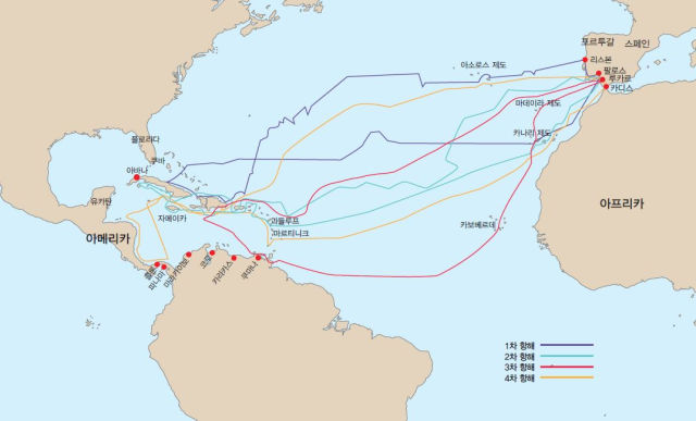
콜럼버스의 네 차례 항해
콜럼버스의 신세계 발견에 관한 수많은 물음 중에서 열대학과 관련하여 가장 흥미로운 질문은 “콜럼버스는 왜 서쪽이 아닌 남쪽으로 항해했을까?”이다. 항해 과정에서 그가 한시라도 잊지 않았던 대단히 중요한 원칙이 있다. ‘경도’보다는 ‘위도’가 항해의 방향을 설정하는데 있어서 가장 기본적인 지침이라는 점이다.
Four Voyages of Columbus
Among the numerous questions about Columbus' discovery of the New World, the most interesting question regarding tropical science is, "Why did Columbus sail south, not west?""There is a very important principle that he did not forget for a moment during the voyage." The most basic guideline for setting the direction of navigation is 'latitude' rather than 'longitude'.
마젤란 항해 지도
마젤란 항해의 가장 중요한 목적은 몰루카 제도의 향료 획득을 위한 새로운 항로의 개척이었다. 그렇다면 왜 그는 몰루카보다 한참이나 북쪽에 있는 필리핀으로 항해를 해서 결국 자신의 생명까지 마감하게 되었을까?
Map of Magellan's Voyage
The primary objective of the Magellan voyage was to establish a new trade route to access spices from the Moluccas Islands. However, Magellan ended up sailing to the Philippines, which is considerably north of the Moluccas. This decision ultimately cost him his life. Why he did?
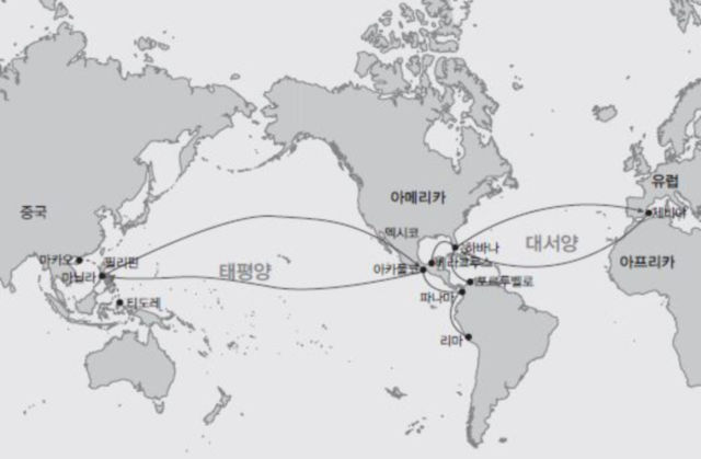
마닐라-갈레온 무역 항로
마닐라 – 아카풀코 갈레온이라고 하면 무역에만 초점을 맞추는데 이는 동전의 한 면만 보는 것이다. 그리스도교의 전파와 무역은 떼려야 뗄 수 없는 스페인 식민화 사업의 본질이었다. 이는 1565년부터 1815년까지 250년간 지속되었다.
The Manila-Galleon Trade Route
The Manila-Acapulco Galleon trade route focused solely on commerce, representing only one aspect of the larger picture. The spread and exchange of Christianity played a crucial role in the Spanish colonialization endeavor. It lasted 250 years, from 1565 to 1815.
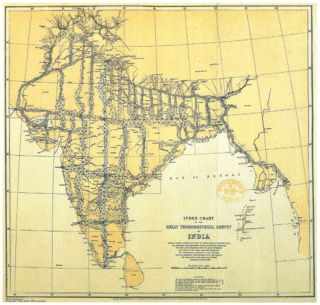
영국의 인도 대삼각측량사업
영국은 1790년대부터 대삼각측량사업이라는 새로운 지리측정법을 개발하여 인도의 자연지리를 정밀하게 조사・측정했다. ‘제국 만들기’를 위한 실용적 도구로서의 지리학과 지도학이 등장하게 된 것이다.
Great Triangle Survey of India in the United Kingdom
Since the 1790s, the United Kingdom has developed a new geographical measurement method called the Great Triangle Survey Project to accurately explore and measure India's natural geography. Geography and cartography have emerged as practical tools for empire-building
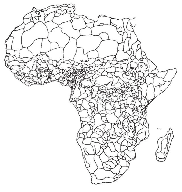
아프리카의 부족별 분포
아프리카에 오랫동안 살아왔던 수천 개의 부족들은 각자의 고유한 언어, 신앙, 예술과 지식을 발달시켜왔다.
Distribution of Tribes in Africa
Thousands of tribes that have long lived in Africa have developed their own languages, faiths, arts, and knowledge.
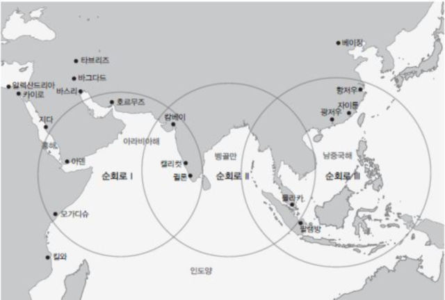
13~14세기 세계체제
13세기 고려의 해양무역은 취안저우와의 무역을 통해서 첫 번째 하위체제에 포섭되었다. 조선 시대도 초기에는 이런 체제를 유지했지만, 명나라 정화의 일곱 차례에 걸친 ‘남해 원정’(1405-1433) 이후로 해금 정책을 실행하면서, 조선은 전 지구적 열대 해양무역 네트워크와 단절되었다.
The world system of the 13th and 14th centuries
In the 13th century, Goryeo's maritime trade was integrated into the first sub-system through trade with Quanzhou. During its early days, the Joseon Dynasty maintained this system, but the Ming Dynasty implemented a ban on maritime trade after seven rounds of 'South Sea expeditions' (1405-1433). Under the Ming Dynasty's influence, Joseon was isolated from the global network of tropical marine trade.
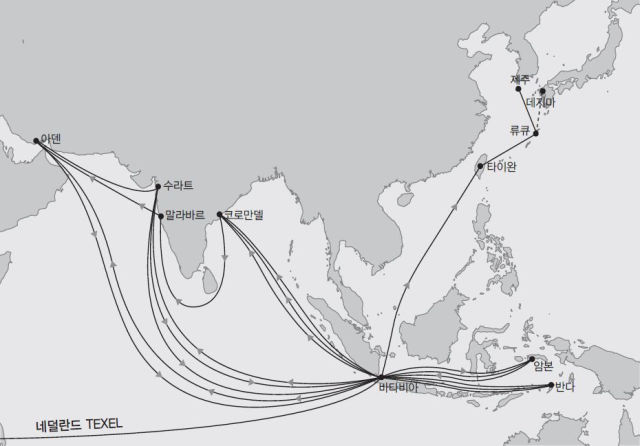
스페르베르호 무역 항로
하멜(Hendrik Hamel)을 포함하여 65명이 승선했던, 네덜란드동인도회사 소속의 스페르베르(Sperwer)호가 1653년에 제주도에 표착했다. 스페르베르호는 네덜란드의 텍셀(Texel) 무역항을 떠나 희망봉에서 인도를 거치지 않고 바로 동남아시아로 항해했다.
Sperwer's Trade Route
Sperwer, a Dutch East India Company ship with 65 people on board, including Hendrik Hamel, landed on Jeju Island in 1653. The Sperwer departed from the Dutch trading port of Texel and sailed directly to Southeast Asia without passing through India at the Cape of Good Hope
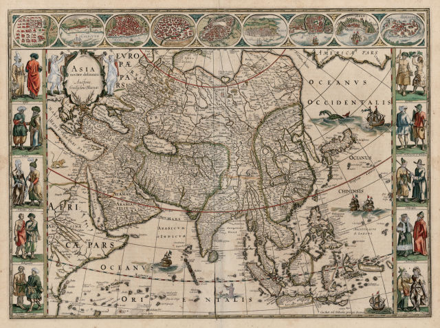
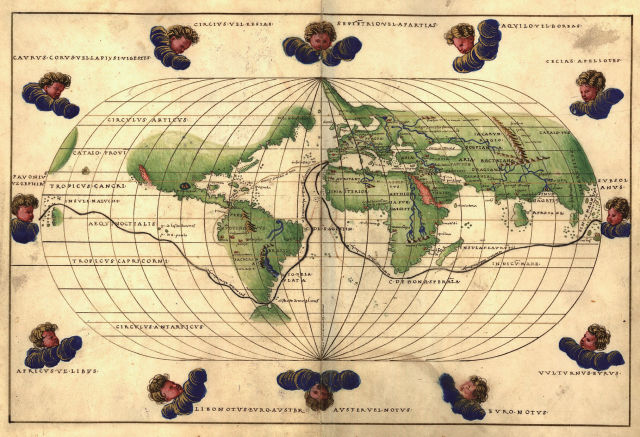
블라외의 아시아 지도
헨드릭 하멜 일행은 당시 유럽에서 널리 알려졌던 지도 제작자 블라외(Willem Blaeu)가 만든 이 지도를 갖고 있었다. 대체로 한 나라에 대해 아는 것이 거의 없을 때, 지도는 그 나라의 이미지를 좌우하는 데 일차적인 근거가 된다. 조선은 이 지도에서 섬으로 나와 있을 뿐만 아니라, 타이완에서 류큐를 거쳐서 일본으로 이어지는 섬들에 의해 가로막혀 있다. 이 지도는 네덜란드를 비롯하여 유럽인들에게 조선은 바다를 통해 접근하기가 쉽지 않은 나라임을 보여준다.
Blaeu's map of Asia
Hendrick Hamel and his group possessed a map created by the renowned European cartographer Willem Blaeu. Usually, when you know very little about a country, a map serves as the primary basis for forming its image. Not only is Joseon listed as an island on this map, but it is also surrounded by islands that stretch from Taiwan through the Ryukyu Islands to Japan. This map shows that for the Dutch and Europeans, Joseon is a country that is not easily accessible by sea.